


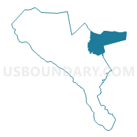
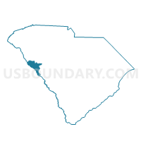
Bethany Voting District, McCormick County, South Carolina
About
Outline

Summary
| Unique Area Identifier | 666352 |
| Name | Bethany Voting District |
| County | McCormick County |
| State | South Carolina |
| Area (square miles) | 39.59 |
| Land Area (square miles) | 39.59 |
| Water Area (square miles) | 0.00 |
| % of Land Area | 99.99 |
| % of Water Area | 0.01 |
| Latitude of the Internal Point | 33.95454900 |
| Longtitude of the Internal Point | -82.14522400 |
Maps

Graphs
Select a template below for downloading or customizing gragh for Bethany Voting District, McCormick County, South Carolina


Neighbors
Neighoring Voting District (by Name) Neighboring Voting District on the Map
- Brunson Voting District, Edgefield County, SC
- Callison Voting District, Greenwood County, SC
- McCormick No. 1 Voting District, McCormick County, SC
- McCormick No. 2 Voting District, McCormick County, SC
- North Side Voting District, Edgefield County, SC
- Plum Branch Voting District, McCormick County, SC
- Sandridge Voting District, Greenwood County, SC
Top 10 Neighboring County Subdivision (by Population) Neighboring County Subdivision on the Map
- McCormick CCD, McCormick County, SC (5,759)
- Kirksey CCD, Greenwood County, SC (2,035)
- Troy CCD, Greenwood County, SC (2,010)
- Pleasant Lane CCD, Edgefield County, SC (872)
Top 10 Neighboring Unified School District (by Population) Neighboring Unified School District on the Map
- Greenwood School District 50, SC (58,872)
- Edgefield County School District, SC (26,985)
- McCormick County School District, SC (10,233)
Top 10 Neighboring State Legislative District Lower Chamber (by Population) Neighboring State Legislative District Lower Chamber on the Map
- State House District 13, SC (35,216)
- State House District 82, SC (34,746)
- State House District 12, SC (31,604)
Top 10 Neighboring State Legislative District Upper Chamber (by Population) Neighboring State Legislative District Upper Chamber on the Map
Top 10 Neighboring 111th Congressional District (by Population) Neighboring 111th Congressional District on the Map
Top 10 Neighboring Census Tract (by Population) Neighboring Census Tract on the Map
- Census Tract 9702.02, Edgefield County, SC (7,439)
- Census Tract 9202, McCormick County, SC (5,759)
- Census Tract 9710, Greenwood County, SC (2,035)
- Census Tract 9709, Greenwood County, SC (2,010)
- Census Tract 9702.01, Edgefield County, SC (1,962)
Top 10 Neighboring 5-Digit ZIP Code Tabulation Area (by Population) Neighboring 5-Digit ZIP Code Tabulation Area on the Map
- 29646, SC (28,159)
- 29824, SC (8,535)
- 29835, SC (6,566)
- 29819, SC (1,523)
- 29845, SC (1,104)
- 29848, SC (751)